Tuesday evening is Cinco de Mayo, and the storm peak overlaps with it. Anyone driving in the zone after dark will be sharing the road with holiday traffic on top of active chain controls and deteriorating mountain routes.
Affected Zones
Northern Front Range and RMNP — 10 to 24 inches across the foothills, isolated to 30 inches in the higher mountains of Boulder and Larimer counties. Includes Estes Park, Nederland, Cameron Pass, Red Feather Lakes, and Rocky Mountain National Park. NWS wording: travel could be very difficult, especially Tuesday afternoon through Wednesday morning.
I-70 Continental Divide — 6 to 18 inches, heaviest along and north of I-70: Eisenhower Tunnel, Loveland Pass, Berthoud Pass, Vail Pass, Idaho Springs, Georgetown, Breckenridge, Winter Park. Travel could be “very difficult to impossible.” West of the Divide, Glenwood Canyon and the Vail Valley are also under chain controls and intermittent closures.
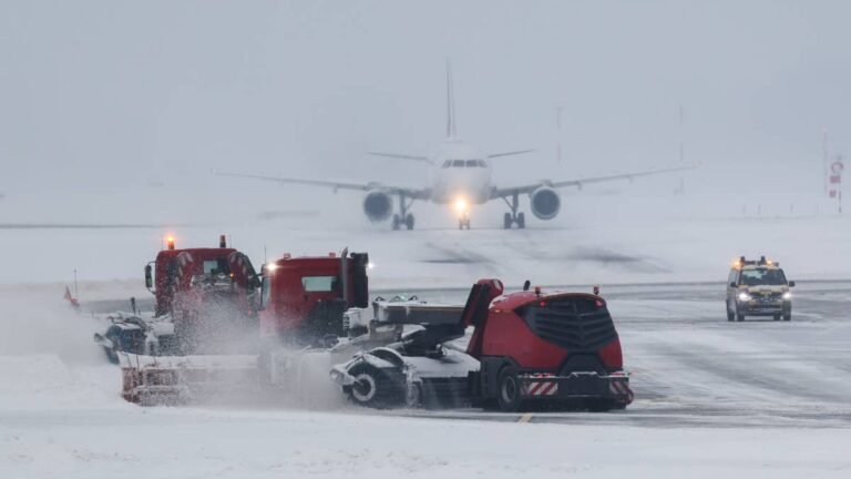
Denver metro and DIA — 4 to 8 inches across most of the metro, locally up to 12 inches near the foothills and along the Palmer Divide. The NWS Denver/Boulder warning explicitly names Denver International Airport in its coverage area. Warning runs Tuesday evening into Wednesday afternoon. Slick conditions for the Wednesday morning commute, sporadic power outages from heavy wet snow on tree branches.
WPC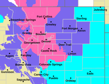
Pikes Peak and southern Front Range — 8 to 14 inches on Pikes Peak and Teller County. 5 to 10 inches across northern El Paso County, including Black Forest and Monument Hill on I-25. Pikes Peak Highway closures are decided ad hoc by the operator. Realistically nobody is driving up Pikes Peak in this weather anyway.
Southern Wyoming — I-80 Summit between Cheyenne and Laramie 7 to 17 inches; Elk Mountain and Arlington 5 to 10 inches; Snowy Range 10 to 18 inches above 9,000 ft; Cheyenne itself 4 to 10 inches. Warnings run through Wednesday. Full I-80 freight corridor detail in the winter storm warning coverage from May 4.
Affected Highways
- I-70 west of Denver — chain controls, possible multi-hour closures Tuesday into Wednesday
- I-70 through Glenwood Canyon — chain controls, intermittent closures
- I-25 Denver to Colorado Springs — slick conditions on Monument Hill
- I-80 Cheyenne to Rawlins — light/high-profile vehicle restriction expected, full closure likely
- US-34 through Rocky Mountain National Park — likely closed Tuesday
- CO-7 / Peak to Peak Highway — chain controls
- Highway 14 over Cameron Pass — summit closure likely
- Pikes Peak Highway — closure possible, status updated by the operator
AAA
Through-Traffic
With the I-70 corridor and Wyoming I-80 both under warning, east-west travel across the central Rockies will be a mess through Wednesday. The realistic detours are I-90 to the north or I-40 to the south. Either one adds several hundred miles depending on where you started. Sierra warnings on the western side of the same storm system also remain active through Tuesday.
If You Are on the Road
- Check before every leg, not the night before.cotrip.org, wyoroad.info, or 511
- For DIA passengers, check flight status before leaving for the airport and budget extra time for de-icing delays Tuesday evening
- For I-70 ski traffic, if you are coming down from Summit County or Winter Park today, leaving early in the day will be easier than waiting for the evening window
- Carry chains regardless of drive type. Colorado’s Traction Law runs through May 31, and AWD doesn’t exempt you
The storm winds down Wednesday afternoon, and on Thursday it warms back up.
Live Road Status
- Colorado: cotrip.org or 511
- Wyoming: wyoroad.info or 511
- DIA flight status: flydenver.com
This article will be updated as conditions evolve.
Sources: NWS Denver/Boulder, NWS Pueblo, NWS Cheyenne, NWS Grand Junction , Weather Prediction Center heavy snow outlook.