Heavy mountain snow is now giving way to powerful winds across the Northern Rockies, with up to 16 inches forecast in Montana’s Anaconda Pintler range and gusts up to 55 mph expected on the Beartooth Highway by Monday.
Peak Driving Danger Window
Monday morning for snow on the western passes, then Monday afternoon for wind on the Beartooth Highway, with the worst road conditions overnight when wet snow refreezes.
A Storm That Turns From Snow To Wind
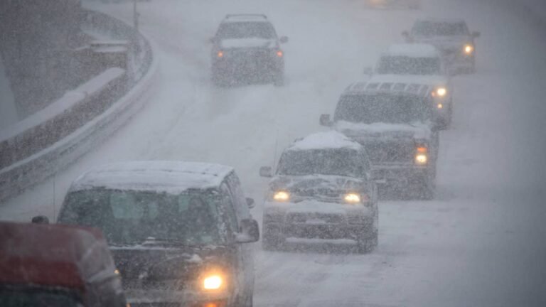
The storm is now shifting from a snow event to a wind event. The weekend brought heavy snow to the high passes of central Idaho and southwest Montana, and road cameras caught it piling up on Big Hole and Lost Trail. By Monday the snow is winding down, and the wind becomes the bigger problem, with gusts to 55 mph on the Beartooth Highway. The cold is what most people will notice. Temperatures are down 20 to 30 degrees, valley highs are stuck in the 40s and 50s, and a frost is possible Monday morning.
The National Weather Service in Missoula holds a winter storm warning above 6,500 feet for the Lemhi, Bitterroot and Sapphire ranges until 9 AM Monday. Snow runs 4 to 8 inches, with up to 16 across the Anaconda Pintler Mountains near Georgetown Lake. The warning grew out of the winter storm watch first posted for these Idaho and West Yellowstone passes. Great Falls added a warning for Northwest Beaverhead County, with more than a foot up high.
Timing
- Overnight into Monday morning: Snow continues on the high passes, with the overnight refreeze the main road threat.
- Monday morning: Snow tapers on the western passes, and temperatures crash 20 to 30 degrees from late-week highs, with frost possible in some valleys behind the system.
- Monday afternoon: Gusts climb to 55 mph on the Beartooth Highway, and to 50 mph across the Snake River Plain and southern Idaho along Interstate 15, enough to shove high-profile vehicles on exposed roads. The Missoula warnings end at 9 AM, the Great Falls alerts at noon, and the Beartooth advisory at 6 PM.
- Tuesday and midweek: A second, colder trough out of the Gulf of Alaska keeps snow levels dipping toward 6,200 feet, so the high country stays wintry even after this round winds down.
Where The Storm Hits The Road
|
Zone |
Alert |
Snow or wind |
Key routes |
|
Anaconda Pintler / Butte and Blackfoot (MT) |
Winter Storm Warning |
4 to 8 inches, 8 to 16 on Anaconda Pintler |
Georgetown Lake area |
|
Western and Eastern Lemhi County (ID) |
Winter Storm Warning |
4 to 8 inches, up to 12 on peaks |
Highway 28, Lemhi Pass, Bannock Pass |
|
Bitterroot and Sapphire Mountains (MT) |
Winter Storm Warning |
4 to 8 inches |
US 93 over Lost Trail Pass |
|
Northwest Beaverhead County (MT) |
Winter Storm Warning |
2 to 6 inches, over a foot up high |
Chief Joseph Pass, Big Hole Pass |
|
Beartooth Highway (MT and WY) |
Winter Weather Advisory |
1 to 3 inches, gusts to 55 mph Monday |
US 212 over Beartooth Pass |
For drivers, the passes carry the risk. US 93 over Lost Trail Pass on the Montana and Idaho line sits deep in the snow band, and Chief Joseph Pass on MT 43 and Big Hole Pass see the same slush near the summit. Lemhi Pass and the climb on Idaho Highway 28 turn from mud to snow first, while Monida Pass on Interstate 15 is the main interstate crossing where snow could still affect travel. The Missoula office told travelers to “consider delaying travel across the backcountry and higher elevations.”
The wind is its own hazard. The NWS Forecast Office Billings has the Beartooth Highway, US 212, under an advisory for light snow and gusts climbing to 55 mph. Pocatello added a wind advisory for the Snake River Plain and southern Idaho, with gusts to 50 mph through Idaho Falls, Pocatello and Blackfoot along Interstate 15.
What Drivers Should Do
- Check Idaho 511 and Montana 511 for live pass and closure conditions before you leave.
- Carry chains or traction devices if you plan to cross any of these passes.
- On the Beartooth and other exposed routes, keep a firm grip in crosswinds, especially in a tall or light vehicle.
- Pack a winter kit even in summer: blanket, water, flashlight, shovel and warm layers.
- Slow down on bridges and shaded curves, where wet snow refreezes first.
The heavy snow stays a high country story, focused on the passes and peaks. Conditions will keep changing through Monday as the snow gives way to wind. Anyone crossing these routes should check Montana 511 or Idaho 511 first.
This is a developing storm. We will update this story as the National Weather Service revises totals, adds or drops alerts, and as road conditions change through Monday.