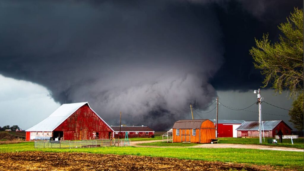
A widespread severe thunderstorm outbreak is unfolding across nine states from the southern Plains into the Upper Mississippi Valley today, Friday April 17, 2026, with the Storm Prediction Center flagging the threat of strong tornadoes, very large hail, and damaging winds through tonight. The SPC has upgraded the southern and central Plains to a Moderate Risk, the second-highest category on the severe weather scale and a designation issued only a handful of times per year. A Tornado Watch is already active across much of eastern Iowa, with a separate Severe Thunderstorm Watch covering eastern Minnesota and central-to-northern Wisconsin including Rochester, Eau Claire, and La Crosse, where hail up to 2 inches in diameter and isolated 70 MPH wind gusts are the primary threats.
Peak danger window: Friday afternoon through Friday night across I-35 from central Texas to Kansas, I-29 through Iowa, and I-94 across Minnesota and Wisconsin, where initial supercells could produce strong tornadoes before merging into a damaging wind squall line after dark.
What to Expect
- Tornadoes: 10% probability across the moderate risk zone, with strong (EF2+) tornadoes possible from initial supercells in Wisconsin, Iowa, and prefrontal storms in Illinois
- Hail: 30% probability of severe hail, with stones up to 2 inches in diameter (hen egg size) reported in active watches
- Damaging winds: 45% probability, with 70 MPH gusts forecast as storms merge into a squall line tonight
- Worst corridors: I-35 (central Texas through Oklahoma into Kansas), I-29 (Iowa), I-80 (eastern Iowa to Illinois), I-94 (Minnesota and Wisconsin), I-90 (southern Minnesota to Wisconsin)
NWS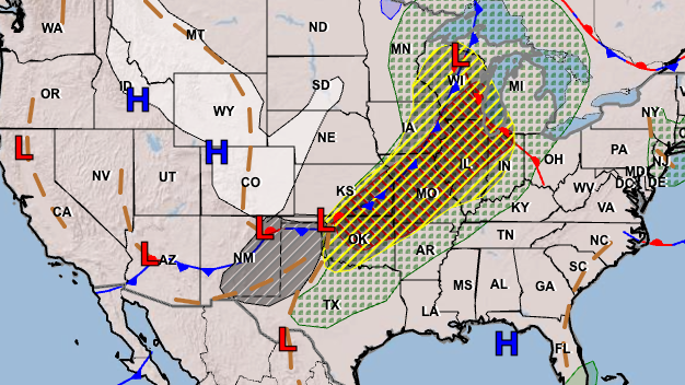
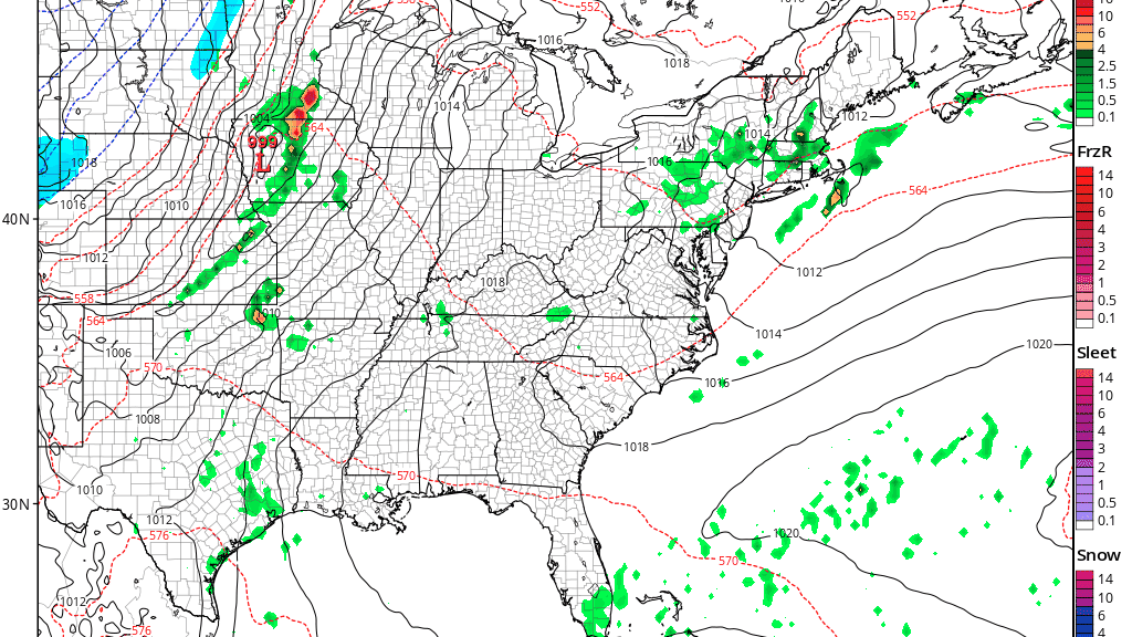
The synoptic setup is textbook for a major outbreak. A strong upper trough oriented from Montana to the Southwest will eject eastward into the Plains tonight, with 40-60 knot southwesterly flow at 850-700 mb intensifying ahead of it by late afternoon. A surface dryline will extend from a High Plains low through the western Oklahoma/Texas panhandle border into central Texas, while a cold front will run from eastern Minnesota into central Kansas at midday. Ahead of these features sits a broad warm sector with mid-to-upper 60s dewpoints and temperatures climbing into the 80s, the recipe meteorologists describe as a strongly sheared and deeply unstable environment.
Road Conditions
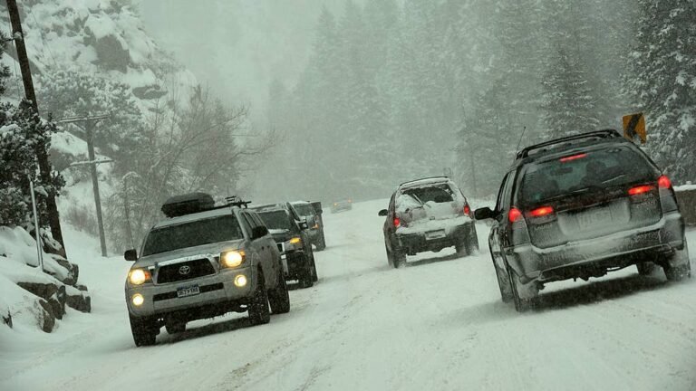
The most dangerous road conditions will arrive in two distinct phases. Initial supercells across the warm sector are capable of dropping golf-ball to hen-egg-size hail with little warning, which can shatter windshields and disable visibility instantly on rural highways. As the cold front overtakes the storms tonight, the threat shifts to a fast-moving squall line with damaging straight-line winds capable of pushing vehicles out of lanes and knocking over high-profile trucks and trailers. Squall lines move at 40 to 55 MPH, leaving almost no reaction time once they appear on radar near your location. Flash flooding is also a real concern with 1-2 inches per hour rainfall rates, and even a foot of moving water can sweep a car off the road.
Hail Damage Risk to Vehicles
Tornadoes get the headlines, but hail is the single most expensive weather hazard for vehicles in the United States. State Farm paid out more than $1.2 billion in auto hail claims nationally in 2024, and Texas, Kansas, Missouri, Nebraska, and Oklahoma recorded the most hail events that year, all of which sit inside today’s threat zone. A single hailstorm can total a vehicle on paper without affecting the engine at all, because adjusters total the cost of every dented panel, cracked light housing, and shattered windshield, and if that figure exceeds the car’s actual cash value, the insurer writes a salvage check. Only comprehensive auto insurance covers hail damage, and insurers will not let you add comprehensive coverage once a severe weather event is already in the forecast. Autoblog’s guide to storm damage and car insurance breaks down exactly what your policy covers and how to document damage for a claim.
Severe Storm Driving Tips
If you are driving in the threat zone today, the most important rule is simple: get off the road before the line arrives. A supercell can cross a highway in minutes, and the difference between baseball-size hail and missing the storm entirely can be a matter of a few miles. If you see a dark, rotating wall cloud ahead of you, do not drive into it. Exit the highway and seek shelter in a sturdy building.
If hail begins, pull over under any available cover. A gas station canopy or parking garage can prevent thousands of dollars in body and glass damage. If a Tornado Warning is issued for your location, never shelter under an overpass. Wind speeds actually accelerate through the narrow channel beneath a bridge, and you lose all debris protection. Pull well off the road, angle your vehicle away from the direction of the storm, keep your seatbelt on, and get below window level. For a fuller breakdown of severe storm driving protocol, Autoblog’s recent severe storm corridor coverage covers the I-35 and I-44 playbook in detail. Monitor local NWS alerts on your phone and have a clear shelter plan before you depart.
Timing
Initial supercells are already firing across eastern Iowa and the upper Mississippi Valley this afternoon, with the Plains threat ramping up through the evening hours. The tornado and large hail risk is highest during the discrete supercell phase from late afternoon through about 9 PM local time. As the cold front overtakes the storms tonight, the threat will transition to a damaging wind squall line that will sweep east through the overnight hours, reaching the lower Missouri Valley and Midwest by Saturday morning. Conditions will improve behind the front Saturday, but additional severe weather is possible Sunday across the Mid-South as the system progresses. We’ll update this article as conditions evolve.