NOAA’s October 15 winter outlook update leans heavily on El Niño. Meteorologists at the National Weather Service told reporters at the outlook briefing that much of the north should expect below normal snow this winter, and private forecasters largely agree. The Climate Prediction Center gives October through December an 83 percent chance of an El Niño stronger than any since 1950 and expects a strong to very strong event to last through March.
Which States Could Face Heavy Snow This Winter
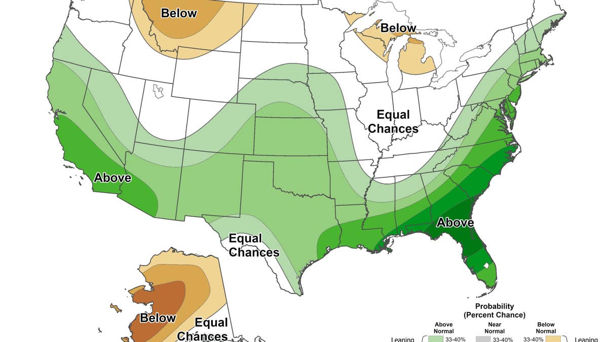
NOAA / Climate Prediction Center
National Weather Service director Ken Graham says a very strong El Niño “will likely bring a southward and eastward shift to the jet stream,” and storms tend to track along it. The clearest snow signal sits over the southern Rockies. CNN notes that record warm oceans give this winter’s storms extra moisture, which raises the potential for unusually heavy mountain snow. Asked where to find a white Christmas, James Belanger, vice president of meteorology for the Weather Company, pointed to the southern Rockies. By region, the December through February precipitation outlook and private forecasts compare like this:
- Arizona and New Mexico: 40 to 50 percent odds of above normal precipitation, with neither a warm nor a cold winter favored.
- Colorado and southern Utah: a weaker signal, mostly 33 to 40 percent. AccuWeather is more bullish, according to the Associated Press, forecasting 10 to 18 days with at least 2 inches of snow in Denver against a historical average of 9, and naming Salt Lake City as the only big metro area likely to see above normal snow.
- Oklahoma and northern Texas: the same 40 to 50 percent odds as Arizona and New Mexico under a neutral temperature signal.
- Southeast: CNN reports that El Niño’s cooler, wetter pattern sets the table for snow, sleet and freezing rain when cold air arrives at the same time as a storm.
How The Outlook Has Shifted Since September
When Autoblog took a first look at El Niño’s snow outlook in early September, the Climate Prediction Center gave October through December a 69 percent chance of an El Niño stronger than any since 1950, and that figure now stands at 83 percent. Ocean temperatures in parts of the eastern equatorial Pacific have also climbed from more than 3 degrees Celsius above normal to more than 4. On the maps, September’s November through January outlook put the strongest wet signal over parts of the Southeast at more than 60 percent, and the new December through February map pushes it to 70 to 80 percent over southern Georgia and northern Florida. The Southwest and southern Rockies remain the most favored areas for snow, as they were in September, and the next set of maps arrives November 19.
East Coast Storm Risk
AccuWeather expects Chicago, Boston, New York and Philadelphia to get about half or less of their usual winter snow. Jon Gottschalck, a branch chief at the Climate Prediction Center, told CNN that some southern storms may turn northeast along the coast and bring heavy rain and snow to the big Mid-Atlantic and Northeast cities if cold air is in place. “These storms could be very strong,” he said.
AccuWeather’s lead long-range forecaster Paul Pastelok points to late January and February as the period to watch, noting that “it only takes one storm to flip the script, especially for the East Coast cities.”
What It Means For Drivers
The seasonal maps show where storms are more likely over three months, and they cannot tell drivers what a given trip will look like. A milder north still gets snowstorms. “It doesn’t erase the risk,” Graham said at the briefing. For the storms that do hit, the National Weather Service this season adds “Particularly Dangerous Situation” wording to select Blizzard and Ice Storm Warnings. It is reserved for high confidence events of historic severity.