NOAA has revised this El Niño upward at every monthly check since June. The Climate Prediction Center now gives October through December a 75 percent chance of producing an event stronger than any on record since 1950, up from 69 percent in its previous update, and holds the odds of a very strong event through fall and winter above 90 percent. The mark it would have to clear was set in 1982-83 and has survived four decades of El Niños since.
Water that warm shifts the winter storm track, and the maps built on it are already out.
Forecasters Now Expect A Stronger El Niño This Season
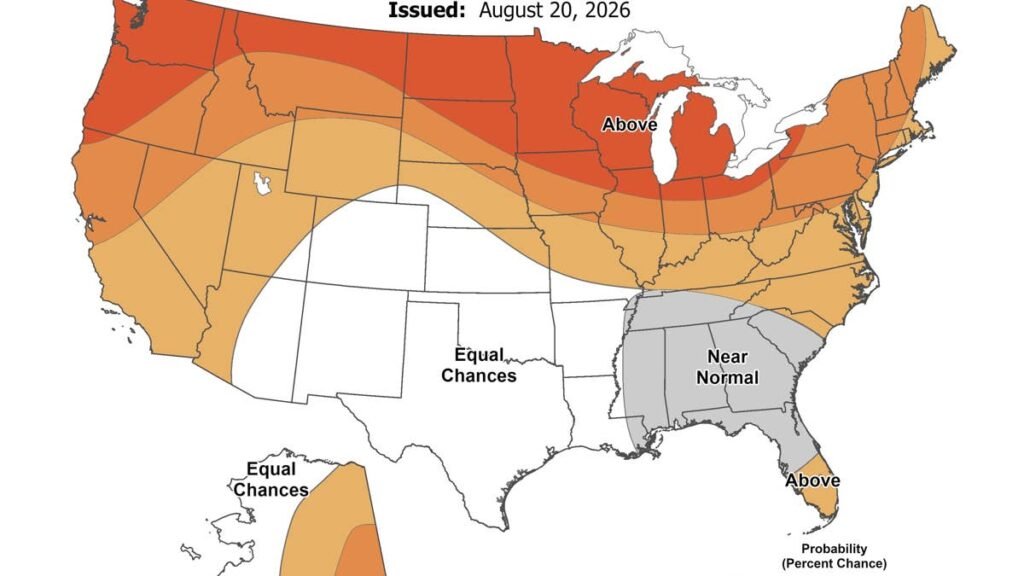
The seasonal package running November through January tilts wet across the southern tier. Its strongest odds sit over parts of the Southeast, clearing 60 percent, with a thinner version of the same signal following the coast north. Most of that ground sees little snow in an ordinary winter, so a wet map and a snowy map are not the same document.
The temperature side of the package cuts against it, with above normal readings favored from the northern tier through much of the West, while the Southeast holds near normal rather than dropping below it. Dry odds concentrate over the northern Rockies and the northern High Plains and thin out toward the Great Lakes. See the temperature map here.
Where The Snow Signal Actually Sits
For an actual snow season, OpenSnow points at the Southwest and southern Rockies. California, Nevada, Utah, Arizona, New Mexico and the southern and eastern reaches of Colorado all carry above normal odds, and the Central Sierra shows the cleanest signal of the group. A southern storm track feeds that pattern, pushing systems through ground high enough and cold enough to keep what lands on it. The strongest part of that signal sits late in the season, with a slow December and above normal snowfall favored from January through March, so the heaviest weeks land after the holiday travel period rather than during it.
Across thefour strongest events ever measured, western snowpack finished anywhere from 73 percent of normal to 139 percent, a range wide enough to cover a very good winter and a very poor one under the same label. The Southwest, the core of the zone favored this year, is the only region that lands above average in all four.
Washington sits outside that group. Moisture there lands close to normal on air warm enough that the Cascades keep a smaller share of what reaches them.
What Super El Niño Means And Does Not Mean
The phrase never came from NOAA, which calls an event at this intensity very strong. Meteorologists reach for the shorthand once the ocean in the tracked stretch of the Pacific passes 2 degrees Celsius above normal, and this event is beyond 3.
A wetter forecast still has to arrive cold. Storms that come in warm drop rain, and at lower elevations out West most of them do. CPC attaches the same line to every update it publishes, that odds shift toward familiar El Niño outcomes without locking in a result anywhere in particular.
What It Means Behind The Wheel
Out West the hazard is a warm system crossing high terrain. Snow lands wet at pass level and hardens overnight into a film thin enough that a driver at highway speed has no visual cue it is there. Chains and a winter compound handle that surface. All wheel drive splits torque across four contact patches, which helps a car put power down and can steady it through a corner while the throttle is open. It adds nothing to braking, and the moment a driver lifts off, grip comes down to the tire alone.
Colorado has its version in statute, covering 126 miles of I-70 between Dotsero and Morrison from September 1 through May 31. All wheel and four wheel drive vehicles can satisfy the Traction Law on tires alone, at 3/16 inch of tread with a mountain snowflake, M+S or all weather rating. Two wheel drive vehicles get no tire option. Under SB25-069 they carry chains or an approved traction device the whole nine months, and better rubber does not substitute. Colorado State Patrol wrote 586 citations last season, 522 of them along the I-70 corridor.
The exposure across the Southeast is different. That region carries the wettest odds on the map at temperatures near freezing rather than below. Stack those two conditions and a storm arrives as freezing rain instead of snow. Most cars there roll on all season rubber, and those compounds stiffen around 45 degrees Fahrenheit, well above the point where water turns to ice. Tires also shed roughly 1 psi with every 10 degree drop, so a set filled in August is underinflated by Thanksgiving without looking any different.