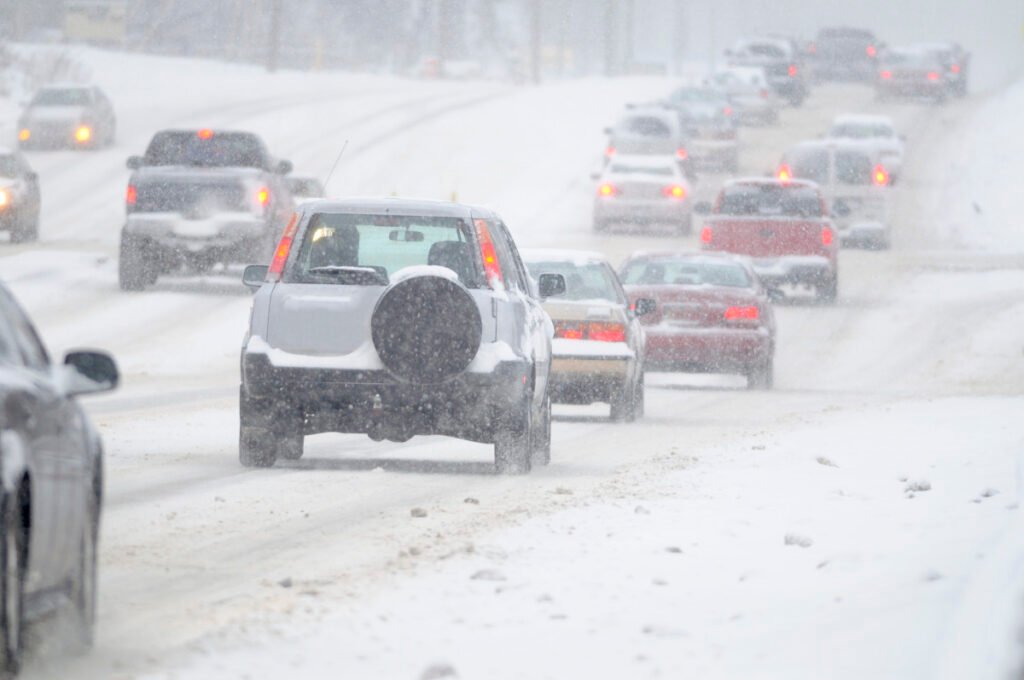
It is Presidents’ Day, traditionally a busy travel holiday, but Mother Nature has other plans for a vast swath of the United States today, February 16, 2026. Major weather systems are causing havoc on both coasts and in the deep South, turning highways into hazard zones and grounding flights.
For automotive enthusiasts and everyday commuters alike, understanding these conditions means knowing when to park the car and, if you must drive, how your vehicle interacts with the elements.
Here is a comprehensive breakdown of the major weather events unfolding right now, followed by critical advice on navigating bad weather and the literal foundation of your safety on the road: your tires.
G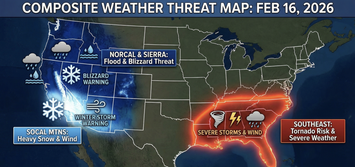
Northern California: The “Level 2” Bay Area Soaker and Sierra Burial
A potent, dynamic storm system is currently slamming Northern California, categorized by meteorologists as a “Level 2” event. This system is bringing a dangerous cocktail of heavy urban rain, severe coastal winds, and massive mountain snowfall.
The Bay Area Impact
For drivers in the San Francisco Bay Area, the commute is treacherous. Moderate to heavy rainfall is causing slick roads and ponding in low-lying areas. A Coastal Flood Advisory is in effect, meaning high tides combined with storm surge could inundate coastal parking lots and roads adjacent to the bay.
The wind is perhaps the greatest hazard for high-profile vehicles today. A Wind Advisory covers coastal zones like Monterey and Big Sur, where gusts are screaming between 50 and 60 mph. These crosswinds can easily push SUVs, trucks, and vans out of their lanes on exposed bridges and coastal highways.
SFO Delays
The weather is also crippling air travel. San Francisco International Airport (SFO) has implemented a Ground Delay Program due to low cloud ceilings and high winds. As of midday, over 174 flights have been delayed, with average wait times exceeding an hour, meaning more travelers may be forced onto the already soaked roads.
Related: Stunning 1953 Chevrolet 3100 For Sale At Just $…
The Sierra Nevada Connection
The same moisture-laden system is colliding with the Sierra Nevada, resulting in dangerous blizzard conditions. Interstate 80, the critical artery connecting Northern California to Nevada, is facing severe restrictions. Chain controls are active, and officials are describing travel as “dangerous to near impossible.” The snowfall projections are staggering. Donner Summit is expected to receive up to 4 feet of snow, while some higher-elevation ski resorts could see upwards of 5 feet by the time the storm winds down. If you do not have a 4WD vehicle equipped with dedicated snow tires and chains, do not attempt travel into the high Sierras today.
Southern California Mountains: From Rain to Whiteout Blizzard
Further south, the same energy trough is impacting Southern California, creating a stark divide between the coast and the mountains.
While the Los Angeles basin deals with rain, the local mountains—specifically the San Gabriel and San Bernardino ranges, including areas near Big Bear and Wrightwood—are under a major Winter Storm Warning that runs through Wednesday.
Today, snow levels are hovering around 6,000 to 6,500 feet, but cold-air advection will drop them significantly tonight through Tuesday, bringing snow down to 4,500 feet. This means major mountain passes, such as the Grapevine (I-5), could see accumulations.
At higher elevations, this is a full-blown blizzard. Forecasts call for up to 2 feet of snow accumulation. However, the snow is only half the story. This system is packing incredibly powerful winds, with sustained speeds of 25-45 mph and gusts expected to hit 60 mph today, potentially reaching 70 mph on exposed ridges by Tuesday.
The combination of heavy, falling snow and hurricane-force gusts will create near-zero-visibility whiteout conditions. Travel is highly discouraged. Furthermore, below the snow line, heavy rain on steep terrain has triggered a Flood Watch, with a high risk of rockslides and mudslides that could block canyon roads.

The Southeast: Tornado Aftermath and Lingering Threats
While the West Coast deals with water in its frozen and liquid forms, the Southeast is recovering from violent atmospheric instability that struck over the weekend.
A severe weather outbreak that began late Saturday and continued into Sunday produced multiple tornadoes across Mississippi and Louisiana. The area around Lake Charles, Louisiana, sustained significant damage. High winds and tornadic activity were powerful enough to overturn a horse trailer, destroy large metal awnings, and snap power poles near towns like Jena and Donaldsonville.
As of Monday morning, crews are still working to restore electricity, with thousands of customers remaining in the dark across Louisiana and Mississippi.
Today, that energy has shifted east. The severe threat has diminished significantly as the system moved into South Georgia and the Florida Panhandle, transitioning from Tornado Warnings to Watches. While the immediate tornado threat is lower today, the system is still producing heavy rain and gusty winds as it exits the coast. Northern Florida is currently experiencing over 12,000 power outages, so drivers must treat dark intersections as four-way stops.
Driving in Severe Weather
When half the country is facing severe weather, the best advice is usually “stay home.” But if you must drive, you need to adjust your technique drastically.
1. The Golden Rule: Slow Down and Back Off It sounds obvious, but speed is the number one enemy in low-traction environments. Your stopping distance increases exponentially on wet or icy roads. Increase your following distance from the standard three seconds to at least six to eight seconds. You need that buffer zone if the car in front of you spins out.
2. Kill the Cruise Control. Never use cruise control on wet, icy, or snowy roads. If your tires hit a patch of standing water and hydroplane, cruise control will detect the sudden loss of resistance and attempt to accelerate to maintain speed, causing a violent and often unrecoverable spin. You need full manual control of the throttle.
3. Managing Hydroplaning If you hit standing water and feel the steering wheel go light (hydroplaning), do not slam on the brakes. Panic braking will lock up the wheels and ensure a loss of control. Instead, immediately lift off the accelerator and gently steer in the direction you want to go. Wait for the tires to re-engage with the pavement before applying gentle throttle.
4. Visibility is Key If your windshield wipers are on, your headlights must be on. It’s the law in many states, but it’s common sense everywhere. It’s not just for you to see; it’s so others can see you in the spray. In heavy fog or falling snow, use low beams or fog lights; high beams will reflect off the precipitation and blind you.
G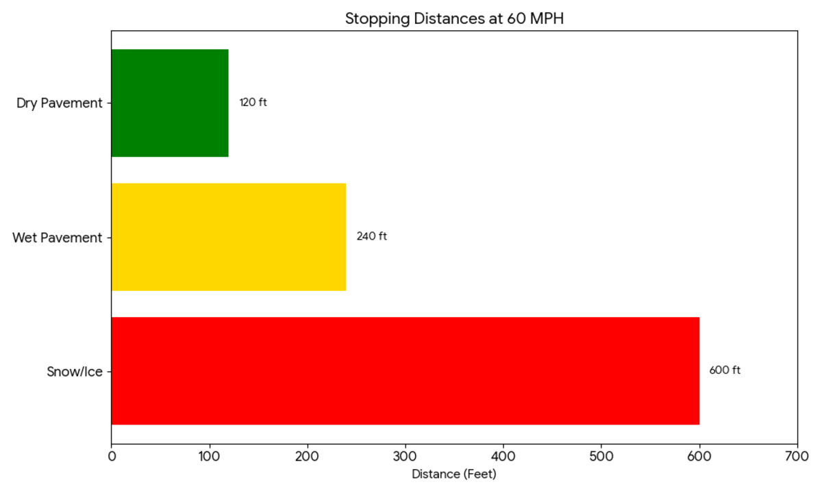
A Tire Deep Dive
All the electronic aids in a modern car, like ABS, traction control, and stability control, rely entirely on four patches of rubber the size of your hand connecting you to the road. In weather like today’s, your tires are your life preservers.
The Tread Depth Check
You’ve heard of the “penny test” (inserting a penny into the tread to see Lincoln‘s head). Forget it. That test at 2/32 inches, which is the legal minimum but utterly unsafe in heavy rain or snow.
Use the “quarter test.” Insert a quarter upside down into your tread grooves. If you can see the top of Washington’s head, you have less than 4/32nds of an inch of tread remaining. You need new tires immediately. Deep tread grooves are essential for evacuating water; without them, your tire will surf on top of the water (hydroplane) at surprisingly low speeds.
Understand Your Tire Type
The “All-Season” tires that came on your car are generally “three-season” tires. They start to harden and lose grip when temperatures drop below 45°F (7°C), even on dry pavement.
- All-Weather Tires: A step up, these carry the “Three-Peak Mountain Snowflake” (3PMSF) symbol, indicating they meet certain severe snow service standards. They are better than standard all-season tires in cold weather.
- Dedicated Winter Tires: If you are driving near the Sierras or SoCal mountains today, these are essential. They use specialized rubber compounds that stay pliable in freezing temperatures and feature aggressive siping (tiny slits in the tread) that bite into ice.
Check Your Pressure
Finally, cold air compresses. For every 10-degree drop in outside temperature, your tire pressure can drop by 1-2 PSI. If you haven’t checked your pressure since the weather turned cold, your tires are likely underinflated, which compromises grip, increases wear, and can lead to catastrophic blowouts.