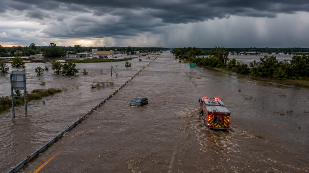
Catastrophic flash flooding has turned parts of southeast Missouri into a disaster zone, and the threat is not over. Slow-moving thunderstorms parked over Reynolds and Iron counties overnight into Friday and dumped what the National Weather Service called a 1-in-1,000-year rainfall, with 8 to 12 inches falling in a matter of hours. The Black River near Lesterville rose roughly 8 feet in a single hour, prompting a Flash Flood Emergency, the most urgent flood alert the NWS issues.
The human toll built fast. According to CNN, dozens of people were pulled from floodwaters, including campers along the swollen Black River, and rescue crews responded to a reported building collapse at a campground. Missouri Governor Mike Kehoe declared a state of emergency and activated Missouri Task Force 1, and the state reported roughly 90 or more rescues in Reynolds County alone. Fox Weather reports the broader flash flood threat now covers close to 40 million people across the Ohio and Tennessee valleys as more storms line up.
The most dangerous window is any time heavy rain falls again on already saturated ground: an additional 2 to 4 inches is possible on soils that cannot absorb it, and forecasters warn that overnight, rapidly rising water on rural roads is where flooding turns deadly.
What to Expect
- Repeated rounds of strong to severe thunderstorms from the central and southern Plains eastward through the Ohio and Tennessee valleys into the weekend, per the Weather Prediction Center.
- Damaging wind gusts of 60 to 70 mph, large hail, and isolated tornadoes in the strongest storms.
- Widespread rainfall of 1 to 3 inches, with locally higher totals where slow-moving, training storms repeatedly hit the same areas.
- Continued flash flooding of small streams and secondary rivers, especially across already hard-hit southeast Missouri, western Kentucky, and Tennessee.
Road Conditions
Flooded and washed-out roads are the defining hazard here. The Missouri Department of Transportation reported that Highway 21 in Reynolds County sustained major damage and closed after a culvert failed, and the State Highway Patrol advised drivers to avoid unnecessary travel on stretches of I-44 and I-55. Water that looks shallow can be deep enough to stall an engine or float a vehicle, and in the worst cases the road surface underneath has already washed away. At night, when visibility drops, it becomes almost impossible to judge how deep or fast the water is until it is too late.
The Missouri Emergency and the Ohio Valley Threat
Southeast Missouri absorbed the worst of it, with towns including Lesterville, Annapolis, Viburnum, and Bixby caught in the emergency zone, along with Johnson’s Shut-Ins and Taum Sauk Mountain state parks. As the frontal boundary sags slowly south and east, the flash flood risk spreads across northern Missouri, southern Illinois and Indiana, southern Ohio, Kentucky, Tennessee, West Virginia, and southwest Pennsylvania. AccuWeather notes this hilly terrain funnels heavy rain through narrow valleys, turning gentle creeks into raging torrents, and the region has seen multiple deadly flash floods in the past year alone.
Flood Driving Tips: Turn Around, Don’t Drown
- Never drive through a flooded roadway. Just six inches of moving water can sweep a person off their feet, and about a foot can carry away most cars.
- More than half of flood deaths in Missouri happen inside vehicles. If you see water over the road, turn around and find another route.
- Be extra cautious at night, when reduced visibility hides both the depth and the current of floodwater.
- If your vehicle stalls in rising water, abandon it and move to higher ground immediately if you can do so safely, then call for help.
- Keep multiple ways to receive alerts, including overnight, and avoid camping or parking along small streams during this stretch.
Timing
The dual severe and flash flood threat continues through the weekend, shifting south on Sunday to cover parts of the Ohio Valley, southeast Missouri, and from Oklahoma into the southern Appalachians. According to ABC News, additional rounds of heavy rain and storms will keep the flood risk elevated from the central Plains to the interior Northeast, with the highest-end threat lingering over the already saturated ground of southeast Missouri.