The storm is now actively hitting the Cascades. The heaviest snow fell overnight Tuesday and continues into Wednesday morning as forecast, and additional accumulations of 3 to 7 inches are expected across the North Oregon Cascades through Wednesday evening. NWS Portland reports snow levels dropped lower than initially forecast, reaching 1,500 feet in Clackamas County, with up to an inch possible above 1,000 feet elsewhere.
A freeze watch has been added for the foothills of the Blue Mountains from Wednesday night through Thursday morning. South Central Oregon Cascades have been downgraded to an Advisory.
All Winter Storm Warnings remain in effect through 5 AM PDT Thursday. Conditions improve Thursday with a dry, mild weekend ahead.
The National Weather Service has Winter Storm Warnings active for the South Washington Cascades, the Northern and Central Cascades of Oregon and the East Slopes of the Oregon Cascades. A deep Pacific trough is pushing cold air and heavy moisture into the range, and snow levels have dropped well below initial forecasts.
Totals above 2,500 feet could reach 21 inches from Marion to Lane counties, with 6 to 12 inches on the east slopes above 4,000 feet. Gusts are forecast at 45 mph. The NWS says to consider delaying all travel.
What To Expect
Snow levels started around 3,000 to 3,500 feet Tuesday afternoon and dropped to 2,500 feet overnight. NWS Portland confirmed they fell as low as 1,500 feet in Clackamas County, putting every major Cascade pass in the heavy accumulation zone. The heaviest rates hit late Tuesday night into Wednesday morning. Additional snow of 3 to 7 inches is forecast through Wednesday evening across the North Oregon Cascades, with 5 to 10 inches on the east slopes. Snow tapers to showers Wednesday night before the system exits Thursday.
NWS Medford downgraded the South Central Oregon Cascades to a Winter Weather Advisory, with 3 to 5 inches expected above 4,000 feet. A Winter Weather Advisory was also issued for the upper east slopes of the Washington Cascades and portions of the Blue Mountains.
Road Conditions
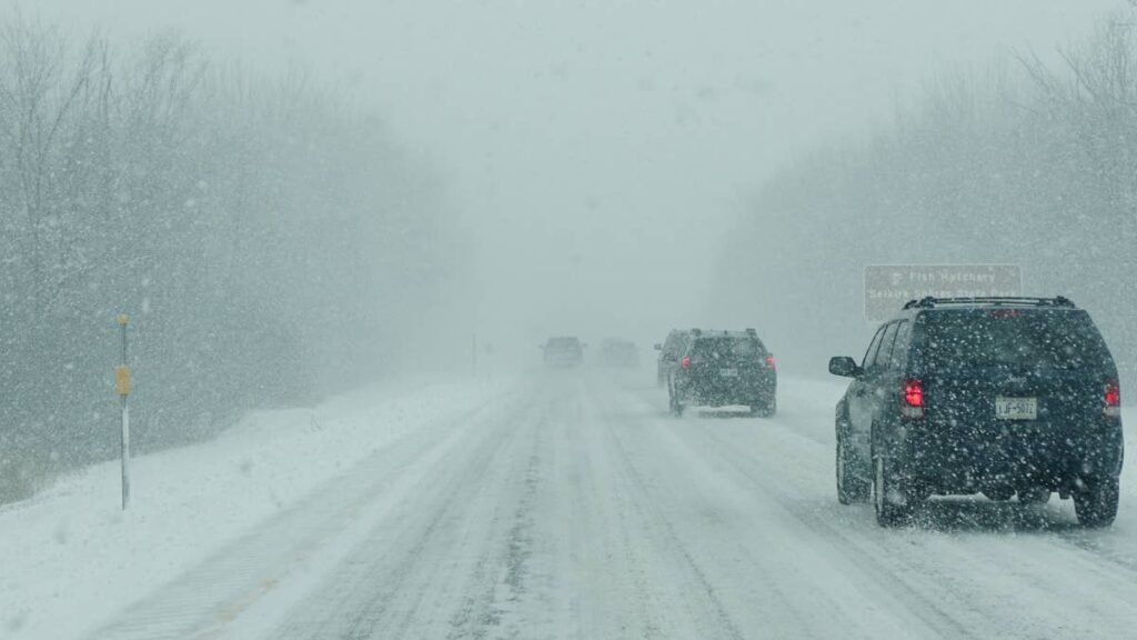
I-90 over Snoqualmie Pass, Highway 2 over Stevens Pass, Highway 58 over Willamette Pass, US-26 over Mount Hood, Highway 22 over Santiam Pass and Highway 20 over Tombstone Pass are all in the direct path. Chain controls are in effect. Full closures remain on the table. Snoqualmie Pass shut down during a similar late-season storm in mid-March and stranded drivers for hours.
Santiam Pass (4,817 feet) sits in the heart of the zone where NWS expects the heaviest totals. Willamette Pass (5,090 feet) has fewer plowing resources than I-5 alternatives and is typically among the first Oregon routes to close and last to reopen. Stevens Pass (4,061 feet) is exposed to the full brunt of southwest flow and quickly becomes overwhelmed if I-90 closes.
Check TripCheck.com for Oregon highway conditions and chain requirements. Check WSDOT Mountain Passes for Washington pass conditions.
Timing
Wednesday morning (now). Heaviest overnight snow is winding down but additional accumulations are building through the day. Passes are at their most dangerous. Avoid mountain travel.
Wednesday afternoon and evening. Snow becomes more showery but does not stop. Plows are catching up after 12-plus hours of sustained snowfall.
Thursday morning. Storm exits. Lingering chain requirements and single-lane operations likely as crews clear the snow. A freeze watch covers the Blue Mountains foothills Wednesday night into Thursday morning.
Thursday afternoon onward. Conditions improve. Friday and Saturday look dry with highs in the mid-60s.
Winter Driving Tips
Oregon and Washington require chains or traction tires on mountain passes during winter conditions. AWD and 4WD vehicles may still need chains. Bring tire chains, a blanket, flashlight, phone charger, water, food and a full tank of fuel before entering the mountains.
All-wheel drive helps you accelerate on snow, but it does nothing to reduce stopping distance on ice. If you are not sure your vehicle is prepared, check your tread depth and make sure your car is ready for winter before heading into the mountains. Brush up on best practices for driving in snow and ice including skid recovery and what to keep in your trunk. If storms like this have you thinking about a more capable vehicle, here are the best cars and SUVs for winter.
If you get stranded, stay with your vehicle. Run the engine in 15-minute intervals, crack a window and wait for road crews.