If you are driving anywhere between Dallas and Wichita this weekend or early next week, you need a plan that accounts for severe weather every single day. The Storm Prediction Center has issued severe thunderstorm outlooks for four straight days, Saturday, April 11, through Tuesday, April 14, across the Southern Plains.
A deep upper-level trough digging into the West is combining with a surge of Gulf moisture so extreme that the Weather Prediction Center says precipitable water anomalies are running three standard deviations above normal across the Plains. Each day brings a new round. The corridor shifts. But the cities in the crosshairs stay largely the same, and the highways connecting them will be under threat for the better part of four days.
The Storm
The ingredients are textbook severe spring weather, and all of them are dialed to high. A longwave trough enters the West Coast this weekend and ejects east across the Plains through early next week. Ahead of it, a southerly low-level jet is pumping Gulf moisture deep into Texas and Oklahoma, with surface dewpoints climbing into the upper 50s and 60s. A dryline across west Texas will trigger Saturday’s initial storms. As the trough sharpens and moves east, the environment becomes increasingly favorable for supercells capable of producing tornadoes, very large hail, and destructive straight-line winds.
Instability builds each day. Deep-layer wind shear strengthens each day. The threat escalates from scattered Saturday to potentially widespread by Monday and Tuesday.
Day by Day
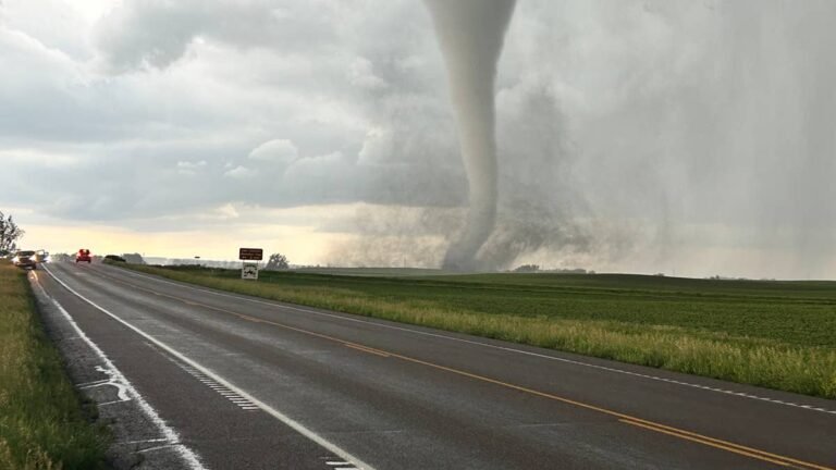
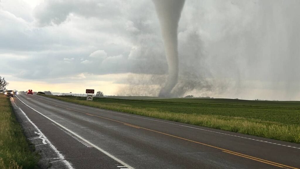
Saturday, April 11. Storms fire along the dryline across west Texas and eastern New Mexico during the late afternoon. Moderate instability and 30 to 40 knots of deep-layer shear support supercells with large hail and severe wind gusts. Coverage is scattered and the footprint is the narrowest of the four days, concentrated from the Permian Basin into the Texas Panhandle and approaching the Oklahoma border.
Sunday, April 12. The threat sharpens. Southwesterly mid-level flow strengthens, and a moist, moderately unstable airmass stretches from the Southern Plains into the Upper Midwest. The greatest potential for severe storms is across the southern and central Plains, where steep lapse rates and moderate deep-layer shear will support supercells with large hail and severe wind gusts. Some model solutions drive a 50 to 60 knot mid-level jet through central and northeast Texas during the afternoon and evening. If that verifies, it opens the door to a substantial severe threat from central Texas through Oklahoma, including supercells with a tornado threat.
Monday, April 13. The biggest day. The geographic footprint expands dramatically. Moderate instability is forecast from north Texas northward into the upper Mississippi Valley. Mid-level flow strengthens further and deep-layer shear increases. Severe storms capable of large hail, damaging winds, and tornadoes are expected across a broad corridor from the Southern Plains into the lower Missouri Valley and upper Mississippi Valley. This is the day when Dallas, Oklahoma City, Tulsa, Wichita, Kansas City, and potentially Des Moines are all inside the threat zone simultaneously.
Tuesday, April 14. An upper-level trough ejects into the southern Rockies and a mid-level jet streak pushes northeastward across the Southern Plains. Strong deep-layer shear and moderate instability from the Southern Plains into the southern Great Lakes create the environment for supercells with large hail, wind damage, and tornadoes. The SPC says an upgrade to their outlooks is possible once confidence increases on the timing of the ejecting trough. The corridor shifts south and east, covering Oklahoma, north Texas, Arkansas, Missouri, and Mississippi.
The Highways
I-35 (Dallas to Oklahoma City to Wichita). The spine of the threat zone. Every day from Sunday through Tuesday puts some portion of I-35 under active severe weather risk. This is the most heavily traveled north-south corridor in the Southern Plains and the single route drivers are most likely to encounter storms on. Sunday afternoon through Monday evening is the peak risk window along this corridor.
I-44 (Oklahoma City to Tulsa to Joplin, Missouri). Runs northeast through the heart of the threat zone on Sunday and Monday. Tulsa and Joplin both sit in the bullseye for consecutive days. Supercell storms moving northeast along this corridor can cross the highway repeatedly as they track with the mid-level flow.
I-40 (Amarillo through Oklahoma City). Saturday and Sunday’s storms will cross I-40 in west Texas and central Oklahoma. This is one of the earliest corridors to see activity each day, as storms fire along the dryline during the late afternoon and track east.
I-20 (west Texas). Saturday’s dryline-initiated storms will affect I-20 from Midland to Abilene during the late afternoon and evening. Large hail is the primary threat along this corridor on Day 1.
I-70 (Kansas). Monday’s expanded threat zone pushes into Kansas, putting I-70 from Salina through Topeka in the risk area. Storms arriving from the southwest during the evening hours could track across this corridor.
When To Drive
Saturday. Morning travel is fine across all corridors. Storms develop late afternoon in west Texas. If you are on I-20 or I-40 west of Abilene, finish your drive before 4 PM CDT.
Sunday. Morning is again your safest window. Storms develop by mid-afternoon across central and north Texas into Oklahoma. If you are on I-35 between Dallas and OKC, plan to be where you are going by early afternoon or wait until well after midnight.
Monday. The most dangerous day for travel. The threat zone is enormous and storms may be ongoing from early afternoon through late evening across virtually every major corridor from Dallas to Kansas City. If your schedule allows, do not drive. This is the day to stay put.
Tuesday. The corridor shifts east and south. Morning travel across the western portions of the threat zone should improve, but afternoon storms from Oklahoma through Arkansas and Missouri will create hazards through the evening. Check conditions before committing.
Why This Outbreak Is Different
The Southern Plains gets severe thunderstorms in April. That is what spring does. What makes this setup demand attention is the duration. Four consecutive days of organized severe weather across the same general corridor means drivers face compounding risk. A hailstorm that cracks your windshield on Sunday becomes a safety hazard when you are driving through heavy rain on Monday. Debris from Sunday’s storms sits on roadways Monday morning.
Power outages from downed lines affect traffic signals and fueling stations. And the same cities, Dallas, Oklahoma City, Tulsa, Wichita, sit in the primary risk zone on two or three of those days. That kind of repeated exposure to major metro areas is uncommon and creates cascading impacts that go beyond what any single severe weather day would produce.
This is also unfolding during what is shaping up to be the most active tornado season since 2011. The SPC has already tracked 43 severe thunderstorm watches nationally in 2026, with northern Indiana alone leading the country in watch frequency. The pattern is aggressive, and this weekend’s setup is the most significant episode of it so far.
What To Do If You Are On the Road
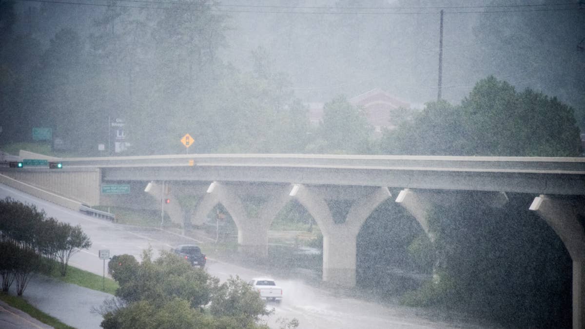
Severe thunderstorms move fast. A supercell can cross a highway in minutes, and the difference between baseball-size hail and missing the storm entirely can be a matter of a few miles. If you see a dark, rotating wall of cloud ahead of you, do not drive into it. Exit the highway and seek shelter in a sturdy building. If you cannot get to a building, pull over, put your seatbelt on, and get below the windows.
An overpass is not a safe shelter; wind speeds are actually higher underneath the span. If hail begins, pull over under any available cover. A gas station canopy or parking garage can prevent thousands of dollars in body and glass damage.
Keep your emergency kit stocked with a flashlight, phone charger, water, and a first aid kit. For a full breakdown on driving in severe conditions, Autoblog’s guide to best practices for driving in dangerous weather covers the fundamentals. Monitor local NWS alerts on your phone, and if a Tornado Warning is issued for your location, act immediately. The safest decision for anyone whose travel across the Southern Plains can wait until Wednesday is to wait until Wednesday.